ProfLT 11.3

A tool designed for drawing and modifying longitudinal terrain profiles
5 
Rating
Your vote:
Latest version:
11.4 See all
Developer:
CADWARE Engineering
Screenshots
1 / 7
Request
Download
link when available

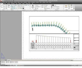
ProfLT is a program which offers functionalities for configuring, drawing and modifying longitudinal terrain profiles and cross sections. The program allows the insertion of points from a coordinates file, and based on the codes or on the 3D model the program generates longitudinal or cross profiles. The configuration options allow the user customization of the profile templates and saving of new templates, so all users can personalize the program depending on the their requirements.

Comments (1)

User

Your vote:

C
Cross section are easy to create

Was it helpful?  yes(0) no(0) | Reply

Related software

ET Surface for ArcGIS
rating

It is a set of tools for ArcGIS that enable the users to create surfaces.

ZWCAD 2012 English
ZWCAD 2012 English
rating

ZWCAD™ is a cost-effective, CAD solution for the AEC and MCAD industries.

Surface Evolver
Surface Evolver
Free
rating

Interactive program for the modelling of liquid surfaces.

Atlas DMT
Atlas DMT
rating

Graphic interactive system for 3D surface modeling

DG Terrain Viewer
DG Terrain Viewer
Free
rating

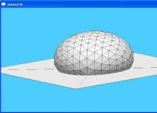
It is a program to view on 3D digital elevation maps mixed with data acquired

Related suggestions

Zwcad portable
Topolt 10.5

Tags

Generate profile 3D polylines Cross profiles Terrain properties Draw profile Zwcad terrain Zwcad 2010 Cross sections Surface profiles Draw